Mapper: Inspection Software with Automatic Reports and 3D Maps
Maedcore's Mapper automates industrial inspections: instant reports, 3D maps, real-time data and cloud. Eliminates manual post-processing.
Written by Maedcore
Mapper: Faster, More Accurate Industrial Inspections — Without the Paperwork
Executive summary: Mapper is Maedcore’s own industrial inspection software. It fully automates the post-processing of inspection data: from field capture to the generation of the final report with charts, 3D maps and histograms. It eliminates manual recording, double verification and writing reports from scratch — the main bottlenecks for inspection companies. Available in an exclusive access programme for selected companies.
The Problem Mapper Solves
Any industrial inspection company — of infrastructure, factories, agricultural facilities or buildings — faces the same tedious process after every inspection:
- The operator takes measurements in the field and records them manually.
- They return to the office and transcribe the data to a spreadsheet.
- The engineer builds charts and generates the report from scratch.
- The report is reviewed, transcription errors are found and part of the process must be repeated.
This cycle can represent hours of low-value work per inspection. With more than 100 measurement points, errors are almost inevitable.
Mapper automates this entire process.
Mapper vs. Traditional Methods
| Mapper | Traditional Methods | |
|---|---|---|
| Post-processing | Automatic | Manual — hours of work |
| Decision-making | In real time in the field | After returning to the office |
| Report quality | Charts, 3D map, histograms | Basic Excel reports |
| Data errors | Eliminated (no transcription) | Frequent due to human interaction |
| Processes | Unified in a single app | Multiple disconnected tools |
| Cost | Minimal (no repetition due to errors) | High (re-inspections and time) |
What Mapper Does: Key Features
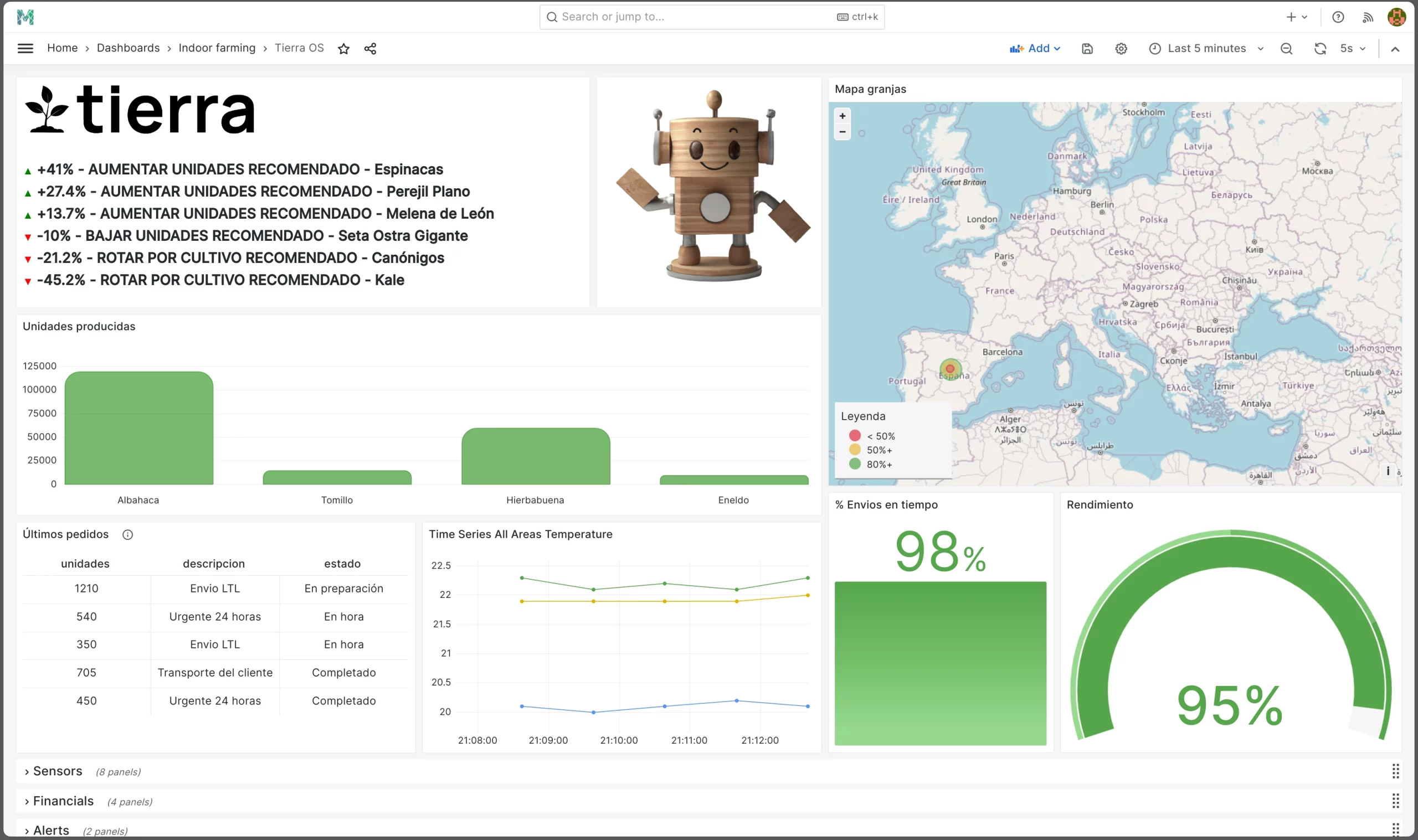
Automatic Report Generation
As soon as field data capture is complete, Mapper generates the report automatically. No Excel, no writing, no copy-pasting. The report includes configurable charts, a 3D map with georeferenced data and distribution histograms.
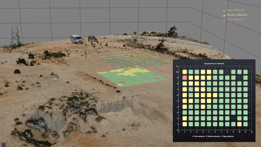
Automatic 3D Mapping
The most distinctive feature: Mapper links each measurement to the GPS position of the measurement point and automatically builds a three-dimensional map. This allows the spatial distribution of inspection data — temperature, amperage, radiation, humidity or any other parameter — to be visualised intuitively and without additional work.
Real-Time Visualisation
Data is visible on the dashboard at the moment of capture. The office engineer can see in real time what the field operator is measuring and make immediate decisions — such as requesting a measurement to be repeated or identifying an anomaly that requires urgent attention.
Cloud-Based Technology
The entire process — capture, processing, storage and reporting — takes place in the cloud. Access is from any internet-connected device, enabling remote collaboration and real-time decision-making regardless of location.
Adaptable Detector
Mapper adapts to the type of sensor or detector each company already uses. It does not require changing measurement hardware — it integrates with existing equipment.
Application Sectors
Factories and industry: measurement of amperage, voltage, temperature and humidity of machines and equipment. Prediction of failures before they affect production.
Facility inspection: real-time inspection and maintenance of infrastructure, allowing immediate action when anomalies are detected.
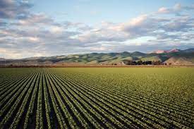
Agriculture: monitoring of field conditions to detect inefficiencies in irrigation, nutrition or the phytosanitary state of crops.
Infrastructure: monitoring of the condition of bridges, tunnels and buildings. Reduces the probability of structural failures by anticipating asset degradation with historical data.
What Users Say
“I wish my operators had more time for more crucial or less repetitive tasks.” — Pedro López, Manager
“I wish I could carry out the inspection faster, focused only on measurements and without taking notes at 40°C.” — Juan Pérez, Operator
“I wish I had real-time data so the engineer can take immediate action without the operator having to return to the inspection point.” — Cristina Gutiérrez, Manager
“I wish I could avoid reviewing notes and transferring them to Excel every time, especially with more than 100 points. It’s very tedious and I make mistakes.” — Marcos Ramos, Operator
“I wish I could present to my clients in a more sophisticated way, with attractive charts or maps, so our company looks more innovative.” — Cristian López, Manager
Mapper Exclusive Access Programme
Maedcore has launched an exclusive access programme for a maximum of 20 selected companies. Companies admitted to the programme receive:
- Early access to the Mapper platform.
- Priority in integrating their suggestions into upcoming versions.
- Sensor installation during the programme free of charge.
- Direct influence on the product roadmap.
If your company carries out industrial, infrastructure, agricultural or facility inspections and wants to eliminate manual post-processing, this programme is for you.
Technologies Used
Product developed with: Artificial Intelligence — Data Analysis — IoT — Sensors — Cloud
Request Access to the Mapper Exclusive Programme
Does your company carry out inspections that still rely on paper notes and spreadsheets? Request your place in the exclusive access programme and be among the first 20 companies to operate with Mapper.
Request Mapper Access | View Data Analysis Projects | Data Analysis Services
Ready to transform your company?
Book a free 30-minute meeting with an engineer.